#Archaeologists use #AI to generate image of Pompeii victim, Archeologists in Italy’s Pompeii have for the first time used artificial intelligence to reconstruct the appearance of one of the victims of the volcanic eruption that destroyed the ancient Roman city nearly 2,000 years ago.

The AI-generated image, released by the Pompeii Archeological Park on Monday, shows a man ducking for cover while holding a large bowl over his head, with a flaming Mount Vesuvius in the background.

It is based on the recent discovery of the remains of a male adult, just outside one of the southern gates of the city, which were lying next to a terracotta mortar that he presumably used as protection.

Archeologists believe the man was killed by a shower of volcanic rocks, in the early hours of the second day of the eruption, while trying to escape towards the sea. He was also carrying a lamp and 10 bronze coins, the park said.

“If used well, artificial intelligence can contribute to a renewal of classical studies, illustrating the classical world in a more immersive way,” the head of the archeological park, Gabriel Zuchtriegel, said in a statement.

The once-thriving city of Pompeii, about 25 kilometres (15 miles) south-east of Naples, was buried in the eruption of Mount Vesuvius in AD 79, preserving buildings, objects and graffiti under metres of ash.

Rediscovered in the 18th century, it is now one of the world’s most significant archeological sites, and one of the most popular tourist sites in Italy, with 4.3 million visitors in 2024, according to the latest statistics.

Reporting by Alvise Armellini; Editing by Keith Weir.


View 121 times

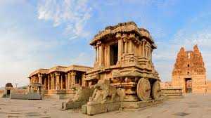
#Archeological ,The #ancient mountain kingdom where fantasy comes to life, The dense forests, twisting rivers and granite peaks of Northern Ireland’s Mourne Mountains have lived many lives and assumed many names.

They’re Westeros in “Game of Thrones.” They’re “Krypton” in the Superman prequel.

They’re also Transylvania in “Dracula Untold,” Sherwood in the upcoming “Death of Robin Hood,” and the Forgotten Realms in “Dungeons and Dragons: Honor Among Thieves.”

As part of the Mourne Gullion Strangford global geopark, this mountain region in Ireland’s northeast achieved #UNESCO recognition in 2023, but relatively small numbers of international visitors come to explore.

However, the lyrically named Kingdom of Mourne — it was never a sovereign state — has been inspiring imaginations globally for more than 75 years.

This sea-lapped landscape of 220 square miles (570 square kilometres) was the real-life inspiration for “The Chronicles of Narnia,” the enduring 1950s novels by Belfast-born writer C.S. Lewis soon to be revived once again. They’ll get their fourth film adaptation in “Barbie” director Greta Gerwig’s “Narnia: The Magician’s Nephew” later this year.
Small and compact

While Gerwig’s “Narnia” is being filmed in England, Northern Ireland has a booming local film industry. Production of Season 1 and 2 of the new “Game of Thrones” prequel, “A Knight of the Seven Kingdoms,” is estimated to have returned more than US$80 million to the economy alone.

“We are a small and very compact country. In fact, we are effectively the size of Greater Los Angeles, but with about 10 per cent of the population,” says Andrew Reid, chief content officer for Northern Ireland Screen.

Only 1.9 million people live in Northern Ireland, but at any one time there will be 1,200 people hard at work on live-action scripted projects.

Thanks to good road infrastructure, crews can head in any direction from a production base in Belfast and quickly access a diverse range of landscapes — as can the fans and tourists who come to the region in their wake.

“You can be on a beach in the morning,” and back in Belfast in the afternoon, says Reid, or “up a mountain one day,” and then on a river, lake or in a forest the next.

Soft hills and rolling farmland

The coastline north of Belfast, with its windswept vistas reminiscent of the Scottish Highlands, has some of Ireland’s most dramatic scenery, including the world-famous Giant’s Causeway.

An hour south of Belfast, the Mourne Gullion Strangford global geopark is a softer landscape, with rolling hills and shadowy dells in which it’s easy for the mind to conjure up magical beasties.

“I have seen landscapes, notably in the Mourne Mountains and southwards, which under a particular light made me feel that at any moment a giant might raise his head over the next ridge,” wrote C. S. Lewis in his essay “On Stories.”

He was more specific in a letter to his brother Warren, writing, “that part of Rostrevor which overlooks Carlingford Lough is my idea of Narnia.”

The Lewis boys spent childhood vacations in Rostrevor, a neat and gaily painted village, now dotted with literary murals, close to the Northern Irish border.

To its north rise the mountains, richly forested in towering sitka spruce, one of the world’s tallest trees, and at their feet lie the still waters of Lewis’s beloved lough, a glacial ford which opens into the Irish Sea.
Thrown by a giant

Lewis wasn’t the first to dream of giants here. From the village, you can saunter past the Fairy Glen (reputed haunt of the “wee folk”) and climb the mountainside to discover spectacular views and a peculiar 50-ton (45-tonne) boulder perched unexpectedly almost 1,000 feet (about 305 metres) above sea level.

The scientific explanation is that Cloughmore (from the Irish for “big stone”) is a glacial erratic, thought to have originated in Scotland and been deposited here by retreating ice at the end of the last Ice Age.

The mythical version is that it was thrown here from across the loch by Finn McCool, the legendary titan who is also credited with building the Giant’s Causeway some 100 miles (160 kilometres) north.

The Mournes were formed by volcanic activity more than 50 million years ago, in tectonic shifts related to those which formed the Causeway’s basalt columns before it.

It was then sculpted by successive Ice Ages, meaning that the mountains – fittingly for a “Game of Thrones” filming location – are a true “land of fire and ice.”

Santa’s cottage and the ‘magic hill’

North of Rostrevor, in the heart of the mountains, Leitrim Lodge has been a frequent filming location, including as the lands north of Winterfell in Season 2 of “Game of Thrones.” (Winterfell itself is at Castle Ward estate, some 30 miles, or 48 kilometres, northwest).

It’s also where, explains Reid, C.S. Lewis went on family picnics and entertained his young cousins with “little stories about dwarf armies and this, that and the other.”

The farmer’s cottage where Arya and the Hound took refuge in “Game of Thrones” Season 4 is a seven-minute drive away, close to “Santa’s Cottage,” Ireland’s “official residence” of Santa Claus. Father Christmas’s appearance in the Narnia books is a seismic event, but in this Hilltown attraction it’s a calendar staple, every November and December.

Locals also head to the “magic hill” near Spelga Dam to experience an intriguing natural phenomenon. An optical illusion here creates what is sometimes called an electric brae: A parked car with its handbrake off will appear to roll uphill on this quiet side road.
The Mourne Wall

During Lewis’s boyhood, the 20-year Mourne Wall building project began. This epic 22-mile (35-kilometre) boundary, built to keep livestock from polluting water supplies, was constructed using the classic dry-stone technique that characterises the area and was completed in 1922.

The granite bulwark runs like a seam across the peaks and is now a popular hiking route taking in seven of the 10 highest 600-metre-plus mountains in Northern Ireland.

Unlike the famous barrier in “Game of Thrones,” however, there’s no “north of the wall”: This wall runs in a circle.

At 354 metres, Hen Mountain is one of the Mournes’ smaller peaks, but it’s achieved new heights of stardom by appearing in the show poster for “A Knight of the Seven Kingdoms.”

Walking along the well-maintained path through the valley on a spring afternoon, the coconut scent of yellow-flowered whin bushes sweet in the air, I have the whole place to myself. It’s hard to imagine this pristine expanse filled with the crowds and clatter of a full-scale HBO production crew. (HBO is owned by Warner Brothers Discovery, the same parent company as CNN).

“We have a strong sustainability element to our work,” says Reid, which means the mountains are left just as they are found. “We have to be grateful for and respectful of the work groups and individuals have done for decades to keep the Mournes clean and protected.”

Tollymore Forest Park

By far the most popular filming location in the Mournes, appearing in everything from 2025’s “How to Train Your Dragon” to the regrettable medieval stoner comedy “Your Highness,” starring James Franco and Natalie Portman, is Tollymore Forest Park.

It’s not hard to see why. This enchanting 630-hectare state park is filled with stepping stones, 18th-century follies and a total of 16 bridges across the babbling Shimna River.

Above the majestic treeline there are panoramic views of mountain and sea, while the Gothic gate arches and intriguing structures such as the hermitage lend it a Middle Earth feel.

Tollymore played a starring role in the very first episode of “Game of Thrones,” which launched 15 years ago this month in April 2011. This is where The Starks discover the dead stag and the orphaned direwolf pups in the woods. It’s also where the Night’s Watch first encountered the White Walkers, in a plot development that would instruct the whole future of the series.
Warm hospitality

A homegrown Irish giant of 6 feet 9, actor and tour guide Flip Robinson was a body double in “Game of Thrones” for the character of Hodor, the Stark family servant. Now he runs Giant Tours Ireland, taking customers on “Game of Thrones” location tours across the region.

It’s “quite incredible how screen tourism has really established itself here,” he says. “With ‘A Knight of the Seven Kingdoms’ coming back here, we were really excited about that.”

Visitors to the Kingdom of Mourne and the Mourne Gullion Strangford Global Geopark will find an invigorated hospitality scene too.

The seaside village of Dundrum, recently named by The Times as one of the best places to live in the U.K., has a food scene that belies its population of 1,500. On the village’s main street, The Buck’s Head, helmed by Michelin star chef Alex Greene, has a Stark-worthy name and top-tier cuisine.

For a more rustic meal, Downpatrick’s Fodder in the Woods, close to “Game of Thrones” locations such as Inch Abbey,” serves its own grass-fed Dexter beef burgers inside a woodland tipi.

Charlie Chaplin was a former guest at the Slieve Donard, a grand Victorian railway hotel in the seafront town of Newcastle, in the shadow of the 850-metre mountain from which it takes its name.

It’s next to the Royal County Down golf club, which last year was namechecked in the Seth Rogen comedy series “The Studio” as “the best golf club in the world.”

Hidden away in the forests of the Enniskeen Estate, just a couple of miles from town, and little known even to locals, is Ireland’s only five-star glamping retreat.

The Enniskeen Estate and Forest Spa, next to the Enniskeen Hotel, which has a fading grandeur of its own, has welcomed A-list guests including fantasy royalty himself, “A Song of Fire and Ice” creator George R. R. Martin.

On its website, Hugh Jackman, star of 2026’s “The Death of Robin Hood,” speaks of his “magical” stay: “I will definitely be coming back.”

By Maureen O’Hare, CNN


View 130 times

#Archeological digs in Amazon provide clues about Indigenous inhabitants before #colonization.

The construction often requires archeological surveys before the paving starts, and some of the latest discoveries have emerged along the BR-156 highway in Brazil’s northern state of Amapa. Among the findings so far from nine dig sites: pottery vases that may be funerary urns, as well as small artifacts that resemble human faces.

“What we now about the region’s past is also tied to the opening created by these projects, which gives our relationship with them a somewhat ambivalent character,” said Lúcio Flávio Costa Leite, who manages the Archaeological Research Center at Amapa’s Institute for Scientific and Technological Research. “At the same time, the knowledge we gain about these sites leads us to pay closer attention to these regions, including by adopting permanent protection measures.”

Scientists say recent research has reinforced understanding of the region’s past not as a human desert, but rather as a landscape shaped by interconnected societies long before Columbus arrived. The material found along BR-156, for example, included pottery in multiple styles and techniques that reflected influences from communities ranging from Brazil’s Para state to the Caribbean.

It’s been cleaned and analyzed by a team working for the National Department of Transport Infrastructure. One of the archeologists, Manoel Fabiano da Silva Santos, said the layers of the Amazon soil he excavated are a historic timeline.

In the upper layers, he found items such as Portuguese porcelain and nails linked to European occupation.

“Digging deeper, we uncovered pottery and ceramics associated with earlier Indigenous presence, marking the site’s transition before and after the arrival of colonizers,” Santos said.

The artifacts will eventually go to Amapa’s state collection, overseen by Costa Leite, which includes about 530,000 pieces. The oldest piece is around 6,140 years old, confirming a long human presence across Amapa, he said.

The artifacts offer insight into how ancient Indigenous societies lived, died and interacted with the rainforest.

“Here is something I often debate with my students -- we usually think of technology as computers and microchips,” Costa Leite said, walking through shelves of ancient pottery. “But all of this required careful reading of the landscape and deliberate choices of materials.”

Indigenous design behind an intriguing monument

One of the most impressive historic areas in Amapa is in the city of Calcoene, where a 1,000‑year‑old stone monument made up of 127 carved monoliths arranged in a circle about 30 meters (98 feet) in diameter, set in open grassland amid the rainforest and bordered by a slow river.

Some have dubbed the Archeological Park of the Solstice the “Stonehenge of the Amazon” for its resemblance to the British monument. Researchers found that the stones were positioned so that during the winter solstice in the Northern Hemisphere they marked the exact point where the sun rises, said archeologist Mariana Petry Cabral, a professor at the Federal University of Minas Gerais who was part of the team that began digging at the site some two decades ago.

“It’s hard to say exactly what all the stones mean, but what we do know is that they are not from the site itself. They were brought from other nearby locations,” she said.

Subsequent research and excavations found the site also served as a burial ground. Radiocarbon dating showed it was occupied for hundreds of years, beginning around 1,100 years ago, she said.

The site, discovered by scientists in 2005, can be visited with prior approval from Amapa’s Institute for Scientific and Technological Research. At the same time, the site is going through the process to become a national park, which will allow more people to visit.

Such archeological sites are protected by Brazilian law, which prohibits them being altered. That adds a layer of protection for surrounding rainforest.

Ancient roads point to connected Amazon societies

Modern archeological and historical ecology research shows that Indigenous peoples not only lived in the Amazon for centuries but also shaped it. They managed and cultivated the landscape through long‑term, sustainable practices, said Eduardo Neves, an archeologist professor at the University of Sao Paulo.

Neves has studied the Amazon rainforest for more than 30 years and, since 2023, has led the Amazon Revealed project, which uses satellite scans to identify archeological sites hidden beneath the forest canopy.

Scans have revealed roads linking archeological sites and buried patterns in the rainforest that point to repeated occupation and deliberate landscape modification. Together, Neves said, the features suggest large settlements.

Archeologists had long suspected such connections, Neves added, but technology has made it possible to see their broader geographic reach. The scans show networks of roads connecting clusters of settlements across the forest, most clearly in southern Amazonas state and Acre.

“When people think of an Indigenous tribe, they often imagine a small village isolated in the middle of the forest. But evidence shows a high degree of interconnectivity linking different settlements,” Neves said.

“Amapa is a key piece that helps us see how dynamic and active these populations were, and how they maintained networks of exchange that have been in place for millennia,” Cabral said.

The Associated Press’ climate and environmental coverage receives financial support from multiple private foundations. AP is solely responsible for all content. Find AP’s standards for working with philanthropies, a list of supporters and funded coverage areas at AP.org.

Gabriela Sá Pessoa And Eraldo Peres, The Associated Press

Felipe Campos Mello contributed reporting.


View 135 times

Francisco de Goya (1746–1828): biography of the Spanish master who died on April 16 and precursor of modern art


View 146 times

Researchers draw parallels between plague victims and COVID-19 pandemic. When researchers examined plague burials at a 17th century hospital in Switzerland, they found that a majority of victims were young labourers, likely of lower social status. According to a new study, the burials demonstrate how socioeconomic conditions can impact mortality during an infectious disease outbreak.

“The ability to recover normal physiological functioning following overexertion or illness is not the same for every individual and this ability is heavily influenced by social status,” the study explained. “If a person cannot ensure their basic needs are met without working constantly, healing or recovery is often foregone.”

For the study, researchers investigated human burials at a monastery-turned-hospital in Basel, Switzerland that was linked to the country’s last recorded plague outbreak, which occurred between 1665 and 1670.

“The COVID-19 pandemic raised many questions about social inequality,” lead researcher and University of Basel osteoarchaeologist Laura Rindlisbacher said in a news release. “We wanted to explore these same questions for our Early Modern sample.”

Osteoarchaeologists analyze skeletal remains to better understand past lives. In Switzerland, DNA analysis confirmed the presence of the plague-causing bacteria Yersinia pestis in several of the remains and on a clay pipe found at the site.

The 15 individuals that were studied had an average age of 17.7 years at death and many of their skeletons displayed signs of physically demanding work, such as wear and tear of the spine and shoulders, indicating they were of lower social status.

“Work strain was of particular interest for us, as this represents one of the most important factors for vulnerability during a pandemic,” Rindlisbacher said. “If somebody can’t forego work to survive, even the danger of contracting a deadly disease cannot stop these persons from working.”


View 152 times

When science said dinosaurs were pea-brained and cold-blooded, humans took their demise as proof of the superiority of warm, clever mammals. By the late 20th century, though, the notion that the dinosaurs died out because they were slow and stupid was falling apart on two fronts: more and more fossil evidence pointed to their having had high metabolisms and sophisticated behaviour, and geologic evidence suggested they had been wiped out in a sudden cataclysmic asteroid impact, rather than slowly undone by any evolutionary inadequacies.

If dinosaurs were strong and intelligent — if humans didn’t really deserve to inherit the Earth from them — then their death in a cosmic freak accident represents unimaginable loss. What if humans were to lose their dominion over the planet, too? What if, in our case, it does turn out to be our own fault?

In the early ‘90s, the sitcom “Dinosaurs” started as a kid-friendly program about a blue-collar family of anthropomorphic dinosaurs and ended with the characters facing certain death in a deep freeze brought about by overdevelopment. It was an unsubtle but prescient look at dinosaurs’ new role as avatars for humans living through what feels like their own creeping apocalypse — call it extinction anxiety.

“They lasted for a long time, were hugely successful and diverse, but now (apart from the birds) are gone,” said Chris Manias, historian of science at King’s College London who wrote a book about paleontology in public life. “They lend themselves to a sense that even the most powerful and dramatic creatures, and the most extraordinary worlds, have an ending.”
Why we fear, respect and mourn dinos

Humans have long loved dinosaurs because their very existence feels stranger than fiction, Manias said.

BC-era humans had an idea dinosaurs existed, even if they didn’t quite know what to make of their monstrous bones. But paleontology didn’t really get going until the 19th century, when fuller fossils were uncovered and experts started to call these massive lizard-looking things dinosaurs, said Vicky Coules, a researcher at the University of Bristol in the U.K. who studies how dinosaurs became visual icons. The idea that we shared a common planet shocked people at the time.

In the mid-1800s, the British sculptor Benjamin Waterhouse Hawkins built immense models of dinosaurs based on fossils and fragments, though they more closely resembled existing reptiles than the giants we now know they are. Their height and heft frightened and thrilled spectators, earning dinosaurs a permanent place in the public imagination, Coules said.


View 170 times

The tragic tale of Harold, the king who lost #England to William the #Conqueror in an infamous battle, still looms large in British popular culture. But that story may need a reset, according to new research.

The Battle of Hastings in 1066 ended the short rule of Harold, the last Anglo-Saxon king, and ushered in William, Duke of Normandy, as England’s leader, forever changing the country, as the well-worn story is told on TV, podcasts and in classrooms. New analysis of manuscripts, however, casts the nature of Harold’s devastating defeat in a fresh light.

The arduous 200-mile (322-kilometre) march that King Harold and his men made before facing off with William, which supposedly left his troops depleted and ill-prepared to fight, never actually happened, says Tom Licence, a professor of medieval history and literature at the University of East Anglia in the United Kingdom. Instead, Licence argues, the troops made that journey southward by ship.

“1066 is still one of the few dates that virtually everyone knows,” said Rory Naismith, a professor of early medieval English history at the University of Cambridge in the United #Kingdom who wasn’t involved in the research. “It is a watershed in English #history, when one political regime was defeated and very soon replaced by another, with huge consequences for the cultural and institutional identity of the kingdom. The developments of 1066 are therefore crucial to understanding everything that came after.”

Reexamining the record

The idea that Harold’s men covered nearly 200 miles in 10 days after a hard-won battle at Stamford Bridge, near York, against Viking leader Harald Hardrada, another rival for the throne, had long struck Licence and other historians as improbable, given the distances involved.

The story of the dramatic overland march was largely a Victorian interpretation that had stuck, Licence said. Its origins stem from a misunderstood reference to Harold’s fleet being sent home in the Anglo Saxon Chronicle, an account of key events written in old English by clergy of the time. In the earlier interpretation, “sent home” was assumed to mean disbanded, with ships sent home to their port of origin. While reviewing the chronicle Licence found repeated reference to home, meaning London, where King Harold was based.

“It dawned on me that when he says, ‘The fleet came home,’ he doesn’t mean the fleet was sent to its various ports. The fleet was sent to its home, London,” he said, referring to one of the authors of the chronicles

To recap: Harold first sailed his fleet northward, Licence said, where he successfully battled the Viking leader Harald Hardrada and his Norwegian force on September 26, 1066. He then returned with it to London. “Rather than exhausting his men on that march south, which of course has been blamed for the English defeat, he had the chance to rest them,” Licence added.

Then, Harold and some of his men traveled overland south toward Hastings to confront the Duke of Normandy. Meanwhile, Licence argued, Harold also sent ships to Hastings to attempt a pincer movement to trap William from the south, but the fleet arrived too late to change the course of the devastating battle that took place on October 14.

Naismith said he agreed with the new interpretation. “The English had a large seagoing fleet of ships, and there is plentiful evidence for sailing up and down the east coast in the era of the Norman Conquest,” he said. “A larger role for these ships in the events of 1066 makes a lot of sense and demonstrates Harold’s ability to use the resources available to him.”

The English army’s march southward has always been part of Harold’s romantic identity, said Duncan Wright, a senior lecturer in medieval archaeology at the Newcastle University in England. Harold is known as the last Anglo-Saxon king who strove valiantly against invading threats, but whose efforts were ultimately futile, Wright added. The march has inspired large-scale reenactments, including one in 2016 for the 950th anniversary that involved 1,066 people.

“Indeed, the English today remain very fond of a ‘brave loser,’” he said via email.

“This new reading also goes to show the lasting legacy of Victorian understandings of the past, and the way in which factoids can develop into historical canon; when we question such traditions, it can result in valuable new comprehensions of the past, as we see here,” he added via email.

The new interpretation shows that King Harold was a competent commander, Licence said, not reckless and impulsive: “I think it was a coin toss, really. It could have been William that day. It could have been Harold.”

Historians have debunked another long-standing story associated with the Battle of Hastings. A famous scene in the Bayeux Tapestry, which depicts the battle from a Norman perspective, shows Harold shot with an arrow in the eye. In fact, the earliest sources describe Harold being hacked to death at the hands of four Norman knights.

The Bayeux Tapestry will travel from France and go on display in Britain for the first time later this year at London’s British Museum.

Licence will present his work at a conference at the University of Oxford on Tuesday, March 24, and the research will also feature in a forthcoming biography of King Harold written by Licence.


View 196 times

Pennsylvania Academy of the Fine Arts: A Nation of Artists, a major American art exhibition for the 250th anniversary of the United States


View 201 times

King Harold’s 200-mile march to Battle of Hastings a ‘myth’: research

King Harold’s legendary 200-mile march across England to the Battle of Hastings in 1066 is a “myth” that likely never happened, according to research published Saturday.

In arguably the most famous battle in English history, the Anglo-Saxon leader was defeated by William the Conqueror, who became the first Franco-Norman king of England, at Hastings on October 14, 1066.

The decisive clash, which marked the start of the Norman conquest of England, is depicted in the Bayeux Tapestry, set to be brought to London from France this year.

Ahead of the tapestry’s exhibition, starting in September 2026, new research from the University of East Anglia (UEA) revealed that the tale of Harold’s famed march to the fight was a “misunderstanding”.

The account of the march, as taught in British classrooms and museums, rests on what a UAE historian argues is a misinterpretation of the Anglo-Saxon Chronicle, a written record of medieval English history.

The Chronicle recounts that Harold’s ships “came home”. For at least 150 years, historians understood that to mean the king dismissed his fleet in September 1066.

That shaped the narrative that Harold and his troops were forced to march over 200 miles (320 kilometres) from Stamford Bridge in Yorkshire in the northeast to Hastings on the south coast to ward off the Norman invasion.

But Tom Licence, a professor of medieval history and literature at UEA, found the ships returned to their home base in London and remained operational, which suggests that they were likely used by Harold during his journey and to defend against the invasion.

“I checked the evidence for him having sent the fleet home and found that it was just a misunderstanding. I went looking in the sources for evidence of a forced march and found there wasn’t any,” said Licence, who will present the findings at the University of Oxford on Tuesday.

According to Licence, the story of Harold and his men traversing the vast distance in 10 days is “implausible”.

The historian also pointed to other early accounts which describe Harold sending hundreds of ships to Hastings after William’s landing, suggesting he still had a fleet at his disposal.

“Harold’s campaign was not a desperate dash across England, it was a sophisticated land-sea operation. The idea of a heroic march is a Victorian invention that has shaped our understanding, or misunderstanding, of 1066 for far too long.”

The 68-metre-long (224-foot-long) Bayeux Tapestry, on loan from France, will be on display at the British Museum for 10 months.


View 206 times